From the High Desert
As noted in my last post, we are now in the Malheur National Wildlife Refuge in the high desert of southeastern Oregon. It’s unusually dry here. There is a lot of snow yet on Steens Mountain, which feeds streams and rivers in Malheur, so there should be substantial snow melt still to come. But what is most notable right now is how dry things are here in comparison to other times I’ve been here. Rain is in the forecast tomorrow. While that won’t be ideal conditions for us, I hope it does rain. It is needed.
 The American West is in the midst of a two decade long drought. It’s evident here and in our other haunt, Wallowa County, which is northeastern Oregon. Here, the two major lakes that host the flyway of migrating birds, Harney and Malheur, are both very much reduced in size at the moment. I’m not sure what the interaction is between climate change and this drought all over the west. But it is changed landscape and right now the numbers of birds seem down. A concern.
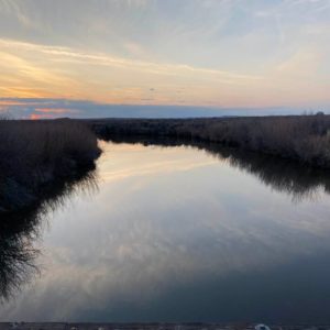
Still, it is beautiful in Malheur’s unconventional way. Here’s a photo Linda took on a sunset drive last evening. The water is the Donner River, which other times in the spring has been a rushing river.
You won’t be able to see it from this photo but there’s a Great Horned Owl in the riverside bushes. There were actually two of them there. And an hour later we saw two more near the Refuge Headquarters. And then this afternoon we spotted an owl nest with at least one young owl in it near us at the Malheur Field Station. So, even if we haven’t seen as many ducks and geese as expected, it’s been a great owl year. Earlier today I saw a couple of Sandhill Cranes as well as several antelope.
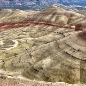 On the way to Malheur we stopped at the Painted Hills Unit of the John Day Fossil Bed National Monument. I’ll include two photos from the “Painted Hills.” The way this has come about is that during volcanic eruptions from the Cascades, millions of years ago, there were layered accretions of volcanic ash. Those of you who were around for the eruption of Mt. St. Helens in 1980 will remember the volcanic ash that spread far and wide then.
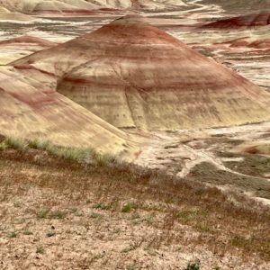 Well the painted hills are layered buildups of volcanic ash. Their different chemical composition accounts for the different colors. While different eruptions account for the different layers. It’s a little like the different sizes of rings in trees, the colors of the ash tells geologists something about climate conditions when the ash was deposited just as variations in the size of tree rings indicate something about climate and rainfall over time.
Before we leave I hope to learn a bit more about the relationship between this drought and climate change and its implications for Malheur and for the bird species that have made it so spectacular in the past.